A comparison of Landsat-8 and Sentinel-2 spectral indices for estimating aboveground forest carbon in a community forest
Abstract
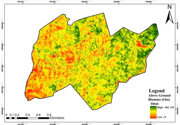
This study aimed to estimate and map the Above Ground Forest Carbon stock in the Salbote Karele Community Forest in Ilam district. The research used field surveys and satellite data from Sentinel-2 and Landsat-8 to determine biomass and carbon stocks. A total of 30 inventory plots covering 283.56 hectares (ha) were surveyed, resulting in an estimated mean biomass of 156.48 ton ha-1 and carbon stock of 73.55 ton ha-1. The biomass was then correlated with five different Vegetation Indices (VIs), computed from Sentinel-2 and Landsat-8 image and used to develop various simple linear regression models. The study found that Sentinel-2 data showed the highest correlation with observed biomass (R2 = 0.76) and lowest prediction error (RMSE = 78.44 tonha-1) compared to Landsat-8 data. The linear regression model developed from Sentinel-2’s NDVI (Normalized Difference Vegetation Index) data predicted a mean AGB of 129.82 ton ha-1 and AGC of 61.01 ton ha-1. This research highlights the importance of using Sentinel-2 data for estimating Above Ground Forest Carbon stocks due to its combination of spectral capabilities and broad applicability. It also shows that the Salbote Karele community forest is of great significance as it stores suitable amounts of carbon..
Sanjeeb Bhattarai
Assistant Professor
I’m an Assistant Professor at Institute of Forestry (IOF), Tribhuvan University (TU); interested in socio-ecological systems, data science and their intersections. I’m most passionate about developing data science tools and practices to understand complex socio-ecological systems, and translating data into informative visualizations.